大地のスクロール:
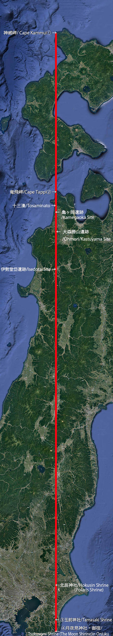
北辰の道ライン / 房の国と蝦夷
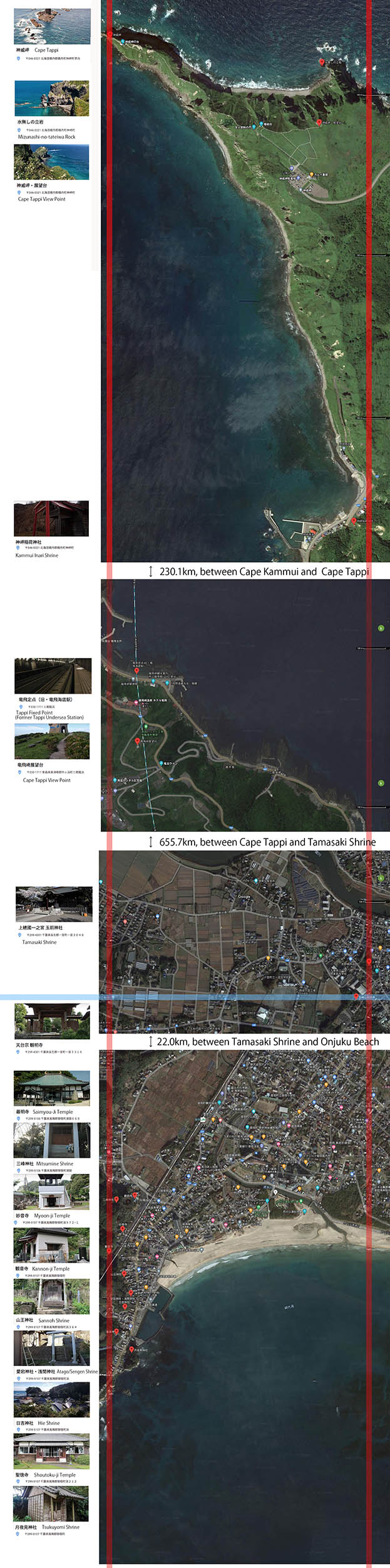
往路③(月夜見神社-神威岬 905.7km・日本最長経線)と復路④(水無し立岩-神崎稲荷神社-玉前神社 885km)
Scrolls on the ground /
Polaris Line between Fusano Kuni and Ezo:
‘140°20'48"E outward line③, between Tsukuyomi Shrine and Cape Kammui’ 905.7km, the longest terrestrial longitude line in Japan and
‘140°21'29"Ehomeward line④between Mizunasi-no Tateiwa Rock and Tamasaki Shrine’885km
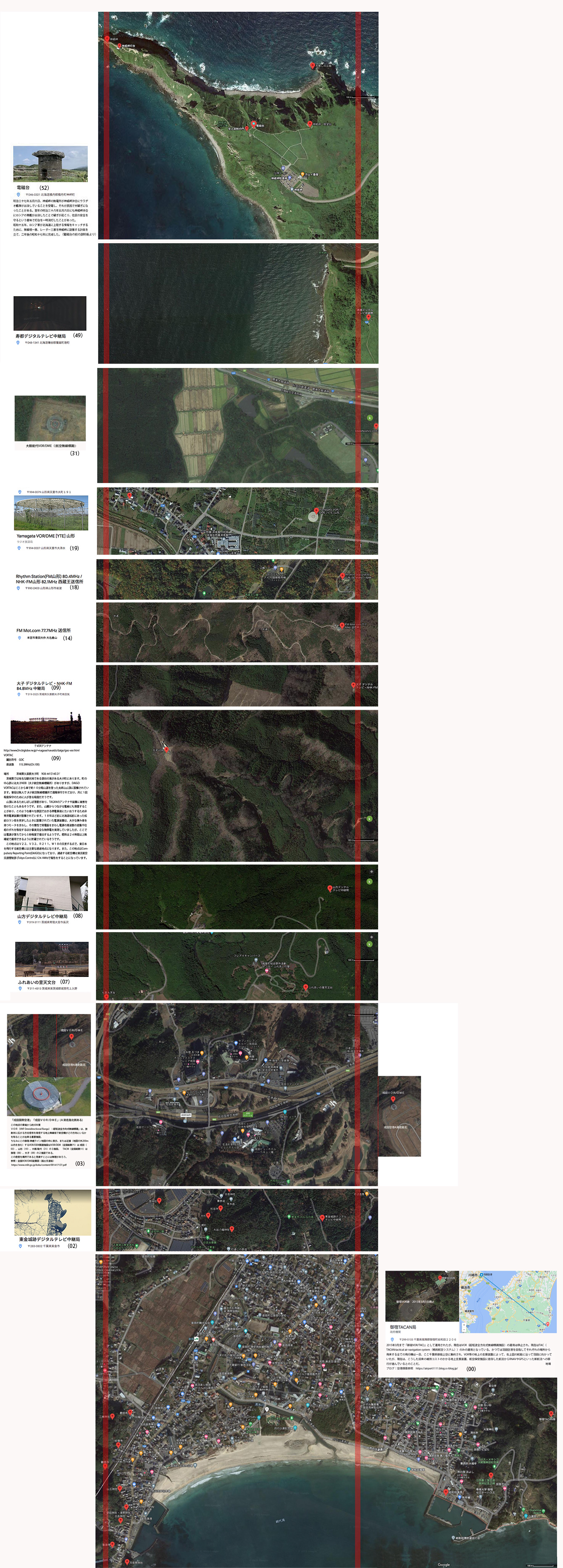
52 51 50 49 48 47 46 45 44 43 42 41 40 39 38 37 36 35 34 33 32 31 30 29 28 27 26 25 24 23 22 21 20 19 18 17 16 15 14 13 12 11 10 09 08 07 06 05 04 03 02 01 00
![]()
1:日本最長経線 :北辰の道 房の国と蝦夷
往路(月夜見神社ー神威岬全長905.7km/日本最長経線 )と復路水無し立岩ー神崎稲荷神社ー玉前神社(全長885km)から構成される北辰の道
夫婦岩ー朝山神社ライン①を拡大し検討している過程で.このライン①が日本の地上部を通過する最長の緯線(東西線)であるとの確信を得たが、その時、それでは日本の地上部を通る最長経線(南北線)はどこにあるかという疑問に囚われた。もし房総を起点に考えると、北方向には東北地方が垂直に立ち上がっており、その先には北海道があるが、これだけ長い垂直線が可能な地形は日本列島の中に他には見つけられない。最長南北線の起点はやはり房総に在るのではないかという予想を得た。試しにライン①の東端夫婦岩から北に針路をとるとすぐに九十九里海岸の沖に出てしまう。そこでライン②上に候補を検討すると、なぜか九十九里海岸から2km内陸に鎮座している終着点である玉前神社を起点にして、北へ向かうと、一時霞ヶ浦の上を通過するが、その後は竜飛岬に至るまで海上に出ることはなく、本州内陸部を通過することが確かめられた。その後、このラインは津軽海峡で海を渡り、北海道上陸後は、内浦湾、さらに積丹半島南部でも海上を通過し、終着点の神威岬に到達するが、それでもこの玉前神社起点の南北ラインは絶妙なバランスと精度で陸地部を通る日本での最長経線が選ばれているとの確信を得た。もしこのラインが古代の人々による意図的な敷設だとしたら、竜飛岬、神威岬など神聖視されてきた地勢上の特異な地点を結んでおり、ライン①とライン②も同様ではあるが、人為を超えた不思議を感じざるを得ない。ただ残念なことに神威岬と玉前神社の間には約1kmの経度(東西位置)の誤差がある。しかし上図のように、往路、御宿網代湾を望む月夜見神社ー神威岬 西側ライン(全長905.7km)と、復路、水無し立岩ー神崎稲荷神社ー玉前神社 東側ライン(全長885km)の二路に分ければこの道の誤差を約100m近くに圧縮することができる。そして往路の月夜見神社ー神威岬全長 905.7km が日本の陸地部を通る最長経線となる。
1:The longest terrestrial longitude line in Japan:Polaris Line between Fusa and Ezo
1: In the process of examining The outward 35°19′10″N line ①, I got the idea that this line is the longest terrestrial lattitude line in Japan. In the mean time, I got another idea what is the longest terrestrial longitude line in Japan. If the origin point would be found somewhere in Boso peninsular district, there is Tohoku district as a long vertical land and Hokkaido in the north. With regard to the longest latitude line in Japan, I cannot find any other possible geographical locations than Boso district as the north end. For trial, drawing a longitude line from the end of Moto Rocks as the east end of line ①, it immediately encounters the pacific ocean on Kujukuri coast. However, if a longitude line starts at the point of Tamasaki Shrine as the end of latitude line② which, is located 2 km inland, it once flies across Lake Kasumigaura then travels through inland until Cape Tappi as the end of Honshu, the main island of Japan. Then, after across Tsugaru Channel, the line lands Hokkaido and travels through two sea areas, Uchiura Bay and Sea of Japan, near Shakotan Peninsular until it reaches Cape Kammui as the north end of this line. However, I have got a stable conviction that this line must be the longest longitude line in Japan in a delicate balance between the land and the sea. If this line would have been decided intentionally, it would really be amazing because on the line, there are several sacred natural points included, such as Cape Kammui and Cape Tappi. It is the fact there is about one Km differences in longitude between Cape Kammui and Yamasaki Shrine and other spots. Considering the whole length of the line(885km), one km differences might not be crucial but if the line is divided into two lines, as the outward line ③ on the west side between Tsukuyomi Shrine located on the hill facing the Pacific Ocean as the south end (905.7km) and Cape Kammui as the north end and the homeward line ④ on the east side between Mizunasi-Tateiwa Rock as the north end and Yamasaki-Shrine as the goal of the line (885km), it can be possible to reduce differences within 150m. [cf. 000 and 052] and the outward line between Tsukuyomi Shrine and Cape Kammui’ 905.7km is the longest terrestrial longitude line in Japan.
2:蝦夷と夷隅の繋がり
竜飛岬と神威岬は古代より神聖視されてきた自然の造形物であるが、このラインには、伊勢堂岱遺跡(031)、亀ヶ岡遺跡(036)など、縄文文化の重要遺跡を発見できる。(上右図参照)縄文遺跡は日本全国に広がっており、北海道にも多くの縄文遺跡が残されている。参考北海道・北東北の縄文遺跡 房総にも千葉市若葉区にある世界最大級の加曽利貝塚をはじめ多くの縄文時代の遺跡がある。またアイヌ文化との関連という観点では、房総にアイヌの古語由来の地名を見つけることができ、(下図参照)「千葉」という地名自体、アイヌの祭礼に使われる神官の幣に似たイナウ(inaw)の古語「chipa」を語源とする説もある。また房総の「房(ふさ・総)」もアイヌ語で「プサ」 pusaに由来するとも言われている。最初、このライン上に現れる房総夷隅と蝦夷とのつながりは唐突のようにも思えたが、以上のような研究、また、矢崎秀行氏の「つげ義春「ねじ式」のヒミツ」響文社2018刊に出逢い、その繋がりについて考察することは、決して荒唐無稽と断じられるようなものではなく、むしろこの国の成り立ちを考える上で喫緊かつ重要な課題であると考えるようになった。
2:The close connection between ‘Ezo' and ‘Izumi’
Cape Tappi and Cape Kammui on this line ③ are nature spots and located on the tips of peninsular, which have been sacred and worshiped since ancient times. Besides these capes, we will find many important Jomon ruins on the line such as Isedotai Site (031)and Kamegaoka Site(036) on the line as well. Needless to say, Jomon ruins are spread national wide. There are several important ruins in Hokkaido as well. cf. Jomon Prehistoric Sites in Northern Japan In Boso district there are a lot of Jomon ruins as well. Kadori Shell Mound in Wakaba Ward, Chiba City is considered as the world’s biggest shell heap. From the point view of connection between Ainu Culture and Boso district, We can find several place names, which derive from Old Ainu language (cf. Diagram on upper right) The name of ‘Chiba’ itself is said to come from ‘Chipa’ meaning ’tassel streamers’ in Old Ainu ceremony, that has changed to ‘Inaw’ now. Besides that, regarding Fusa, another name of Boso district is said to come from ‘Pusa’ in Old Ainu, meaning ’tassel or crop ear’ When I encountered this line, it wasn’t easy to associate between Fusa, Boso district and Ezo, Hokkaido. But knowing these researches and reading the book ‘the secret in ‘Screw Style’ by Hideyuki Yazaki, I have come to think it isn't ridiculous theory but worth considering and researching the connection between Fusa and Ezo.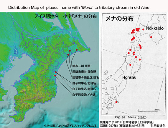
3:北極星と月とニコライ・ネフスキー
この経線ライン③は、まっすぐ北方向に、竜飛岬(38)、ラインの終着点神威岬 (52)を指し示しているが、これは北辰、つまり北極星を指示しているのではないだろうか。実際に北辰神社、同じく北極星を祀っている考えられる星神社が千葉県成田市高倉にこのライン上に配置されている。 (03)一方、南端の房総御宿網代湾には月の神、ツクヨミを祀る月夜見神社が鎮座しており、このことはライン全体に重要な役割を担っていると考える。(00)これまで紹介したライン①と②の東西線は、言うまでもなく太陽の運行に関わることで、昼の世界が表されているのに対し、この経線ライン③が月と北極星の組み合わせによって象徴するものは、夜の世界であろう。太陽神アマテラスによって象徴されるものは、太陽の運行と死と再生であるが、アマテラスの弟、月の神、ツクヨミもまた再生の神で、萬葉集では若返りの霊水「をち水」を持つ者として登場する。 「天橋も 長くもがも 高山も 高くもがも 月夜見の 持てるをち水 い取り来て 君に奉りて をち得てしかも(n.3245)」(天上への橋も長くあって欲しい。高山も高くあって欲しい。月の神の持っている若返りの水を取って来て、あなたに差し上げて、若返らせたいなあ。)
月からやってくる「をち水」の持つ再生力については、「月と蛇と縄文人」寿郎社 2014年で大島直行は、縄文文化が月の信仰と深く結びついていることを解き明かしているが、私は特に貝塚や、盛土遺構が単なる生活の痕跡の結果として形成されたものではなく、祭祀的な目的を持って作られたという見解に共感した。また大島はミルチャ・エリアーデの思想またネリー・ナウマンから直接薫陶を得たことに言及しているが、わたしはツクヨミと「をち水」からロシアの悲劇の天才人類学者ニコライ・ネフスキー を思った。 ネフスキーは大正期に日本に滞在し、アイヌ語・宮古島方言・台湾のツォウ語、古代西夏語研究に精通し、日本の民族学発展に寄与したが、 中でも沖縄宮古島で採集した「をち水」 伝説の紹介(1926 東洋文庫「月と不死」に収録) は有名である。ネフスキーは沖縄宮古島で日本だけではなく、アジア全域に壮大な広がりを持つ「をち水」神話のプロトタイプを見つけたと言えよう。ここで紹介する4本のラインもネフスキーや大島のように汎ユーラシア的視点から考察を進めたい。
3:Polaris, The moon and Nikolai Nevsky
This Longitude Line③ points to Cape Tappi and Cape Kammui in the North direction like a compass needle, in other word, Polaris might be implied and symbolized here. In fact Hokushin Shrine ( Polaris Shrine) is actually fixed on the line, Takakura, Narita city, Chiba prefecture.(003) Mean while, at the south end of the line, there is Tsukuyomi Shrine(Tsukuyomi:the moon god in Japanese Shinto mythology) on the hill facing the pacific ocean. Thinking of the whole lines’ layout these facts are crucial. Latitude line①and②, represent annual solar motion and the world in daylight, on the contrary, this longitude Line③ is suggesting the world after dark by the combination of Polaris and the moon. Amaterasu, the highest goddess of the sun in Japanese mythology represents the solar motion and ‘rebirth’ . Meanwhile, Tsukuyomi, a younger brother of Amaterasu and the moon god has been worshipped as the god of rebirth as well. In Manyo-shu (8th century anthology of Japanese poetry), Tsukuyomi is often appeared as a god with magic rejuvenation water, several times. “The bridge to the heaven should be longer, the high mountain should be higher. I wish to bring magic rejuvenation water gifted from Tsukuyomi, the moon god to you. ( Manyo-shu n.3245)“ The episode of Tsukuyomi and his magic rejuvenation water remind me Nikolai Nevsky , Russian anthropologist famous for his genius and tragic death, who deeply studied Ainu language, Miyako-jima direct, Tsou language, Western Xia language. His researches were always based on Eurasian point of view. His introduction of ‘wochi-mizu’, Magic dew from the Moon story in Miyako-jima Archipelago in Okinawa (1926) made a major impact on the ethnology and literal fields in Japan. I think he found the prototype of the magic rejuvenation water mythology widely spreads in Eurasia and these four lines Iintroduced here should be examined from Eurasian point of view.
4:千葉氏と妙見(北辰)信仰
千葉氏 は10世紀に平家から分かれ、16世紀に至るまで房総(千葉)において、もっとも影響力のある一族であった。房総半島を実行支配した彼らは自分たちの治めた土地の名である千葉を家名とした。また彼らの家紋、月星紋は夜空の北極星と月を表しているが、これは一族の妙見菩薩 (北極星の化身と信じられている)信仰に由来する。(c.f.千葉神社)私はこの北辰信仰(北極星信仰)、はこの房総地方の古い伝統ではないかと想像している。また北辰(北極星)と妙見菩薩の組み合わせは古くからよく知られており、19世紀にもっとも有名であった剣豪千葉周作は千葉氏傍流の子孫であるが、自分の創始した剣法の流派を北辰一刀流と称したが、これも妙見信仰に因んでいると考えられる。 もともと妙見信仰は、インドで発祥した菩薩信仰が、中国で道教の北極星・北斗七星信仰と習合し、仏教の天部の一つとして日本に伝来したものであると言われているが、 さらにアジア北方の遊牧民族に共通な、「天上世界」もしくは「天上神」「運命神」「創造神」を意味するテングリ崇拝 があり、これも北極星・北斗七星信仰と深く結びついていると考えられる。またアイヌ民族には独自の星座や星名、星にまつわる伝承があるが、中でも北極星をポロ・ノチウ(偉大な星)として崇拝していた。関東、東北にに広がる妙見信仰、北辰信仰は上に紹介したニコライ・ネフスキーのように、ユーラシア的な視点から考察されるべきものではないだろうか。
4:The Chiba Clan and Myoken Worship
The Chiba Clan, a branch family of the Taira Clan was the most powerful and influential samurai clan in Boso (Chiba) district between 10th and 16th century. They actually governed Boso district and took their family name, 'Chiba', from the place of their territory. Their kamon, family emblem was 'Gessei' symbolizing Polaris and the moon because they worshipped Myoken, the deification of Polaris suggesting the north direction and the Moon in the night. I guess there would have been an old tradition of worshipping Polaris in this Boso area. (c.f.Chiba Shrine)The combination of Polaris and Myoken has been quite well-known in this country. Shusaku Chiba, a descendant of one of Chiba Clan branches, who was the most famous master swordsman in 19th century, named his new kendo fencing method, Hokushin Itto-ryu, meaning Polaris One Sword Method.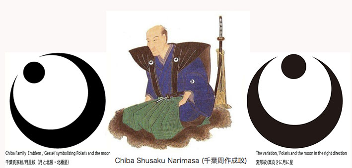
5:夷隅という地名が表すもの
夷隅(イスミ)、蝦夷(エゾ)という地名の漢字表記には夷「イ・えびす」という字が使われており、一般的な解釈では、未開、またまつろわぬ人々の国というような意味になるであろう。 この往路南端の御宿町は夷隅(いすみ)郡に含まれるが、古くはいすみ市も含め夷隅(いすみ)と呼ばれる地域は房総半島の東部のかなり広い部分を占めていたのであろう。このサイトで紹介した東西ライン①と②は出雲と夷隅を繋ぐもので、起点は夷隅の夫婦岩であると考えている。この南北ライン③は夷隅と蝦夷を結ぶ道で、それぞれのラインの東端、南端が直角に交わる場所が夷隅で(いすみ)であり、夷隅という地名には日本の国の形が反映されているのではないだろうか。
5:What ‘夷隅’, Isumi means.
Both old district names of ‘夷隅’, Isumi (Boso peninsular) and ‘蝦夷’, Ezo (Hokkaido) consist of Chinese Character, ‘夷’ that suggests a land of savage or rebellious people in general interpretation. In ancient time, the area called Isumi would have been wider, and I guess the place where Tamasaki Shrine, the end of This Longitude Line③ as a homeward line is located, is now on the outer edge of Isumi city but used to be a part of Isumi, I guess. Those two latitude lines, ①and②connecting Izumo and Isumi and this line ③ consisting of two latitude lines join to latitude lines, ①and②in Isumi and make a right angle in Japan main land. I conjecture that this fact would suggest the meanings of ‘夷隅’, Isumi as the conner land of Japan where savage or rebellious people live.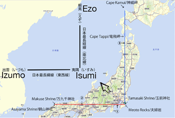
6:「御宿」という地名と「無原罪の御宿」としての「海の星のマリア」
このこのライン③の最南端に位置する月夜見神社は夷隅郡御宿町にあるが、「御宿」という地名は地域の伝承では13世紀中頃、第5代執権北条時頼が諸国遍歴の旅の途中、この地にも滞在し、 ‘御宿せしそのときよりとこと問はば 網代の海と夕影の松’という短歌を詠んだことに因むという。「宿泊したその時頼であるともの言えば、網代の海と夕影の松」または「御宿した時からかと尋ねれば、網代の海と夕影の松」と言う意味にもとれる。時頼が滞在した伝えられている寺は最明寺というが、日本各地に最明寺という寺があり、時頼逗留が伝えられているので、御宿にも時頼が来たことはかなり可能性が高いと言えよう。ところで地名「御宿」と聖母マリアとの関連を考察することは、我が国にキリスト教がもたらされたのは16世紀であり、唐突にも聞こえるだろうが、以下の理由で妥当であると考える。「御宿」はキリスト教においては、「無原罪の御宿り」を意味し、聖母マリアが処女懐胎したこと、人が負うべき原罪の汚れを一切受けることのない存在であることを象徴する言葉である。またこの御宿の地は1609年9月30日のサン・フランシスコ号漂着と地元住民による献身的な救助の地としても有名である。九死に一生を得たロドリーゴ・デ・ビーベロ・イ・ベラスコ前ルソン総督代理と316名の船乗りは、彼らの守護神、聖母マリア、「海の星の聖母、ステラ・マリス」のご加護であると感謝したであろう。もし、この漂着の地が当時から「御宿」と呼ばれていたのなら、彼らにとってこれは聖母マリアの奇跡であり、記録通り、上総国夷隅郡岩和田村沖で遭難し、その後、この地が「御宿」という地名に変更されたらなら、キリスト教禁教の時代、キリシタンによって密かに聖母マリアを讃え顕彰したと考えられないだろうか。つまり時頼到来伝説は事実であったとしても、聖母マリアをカモフラージュするためのアリバイとして使われた可能性があるのではないだろうか。 またこのサンフランシスコ号遭難の地、御宿とこのラインのトップページで紹介したサンフランシスコ・ピークスコSan Francisco Peaksが太平洋を挟んで9653kmの距離を隔てアメリカアリゾナ州のほぼ同緯度に聳えているのも、不思議な偶然の巡り合わせである。
6:Onjuku, ‘御宿’, and ‘Immaculate Conception’ as Our Lady, Star of the Sea
Onjuku, ‘御宿’, the name of a town on the south end of the longitude line ③ where Tsukuyomi Shrine, the Moon Shrine is located, has two meanings. The first one is ‘noble stay’ and the second one is ’ Immaculate Conception’. According to the town official website, it was said that ,Onjuku ‘御宿’was named after the episode of Tokiyori Hojo , the fifth shikken (regent) of the Kamakura shogunate 13th century who was famous for his secret journey over the country. When he stayed in this area he wrote the following tanka, short poem. ‘When I confessed that I was Tokiyori, the man who had stayed here, the sea view from Ajiro bay and the pine trees casting long shadows emerged at dusk. ’ ‘御宿せしそのときよりとこと問はば 網代の海と夕影の松’ On the other hand, the poem suggests another different meaning, ’ When I asked if it has been since the time of Immaculate Conception, the sea view from Ajiro bay and the pine tree casting long shadows emerged at dusk.’ In Onjuku ‘御宿’, there is Saimyou-ji Temple’最明寺’ where it is said that Tokiyori stayed and the legend can be credible considering the fact there are a lot of other temples having the same name as Saimyou-ji Temple’最明寺’ all over japan where Tokiyori stay legend remain, It might sound sudden that Onjuku ‘御宿’ suggest ‘Immaculate Conception’ as the Virgin Mary for Japanese christians. It was 16th century 300 years after from the era of Tokiyori when Christianity was introduced into Japan. However, I think it is quite natural to think of the invisible relationship between ,Onjuku ‘御宿’ and the Virgin Mary. There was the famous story of the wreck of San Fransisco, Spanish Galleon off the coast of Boso and dedicated rescue activities by local people in 1609. It is easy to assume that the 317 survivors, Rodrigo de Vivero y Aberrucia and crew would have very thanked to the Virgin Mary, Our Lady, Star of the Sea as as a guide and protector of seafarers for their lucks after they were rescued. Regarding Onjuku ‘御宿’ as the place name, I think there were two possibilities.The first one was if the survivors were rescued on the beach of the district,which had been called Onjuku already at that time, the survivors and Japanese Christians must have praised the Virgin Mary for her a miracle. The other one was if the survivors were rescued on the beach of ‘Iwata’ village as recorded and then named this area Onjuku ‘御宿’ . It could have been possible because they would have wanted to bless the Virgin Mary secretly under the ban on Christianity between the 17th and 19th century. Besides that, it is also a curious coincidence that there are San Fransisco Peaks (c.f. The top page) located on the same latitude point in Arizona 9,653 km far from the beach of Onjuku where the 317 crew of San Fransisco rescued across the Pacific Ocean.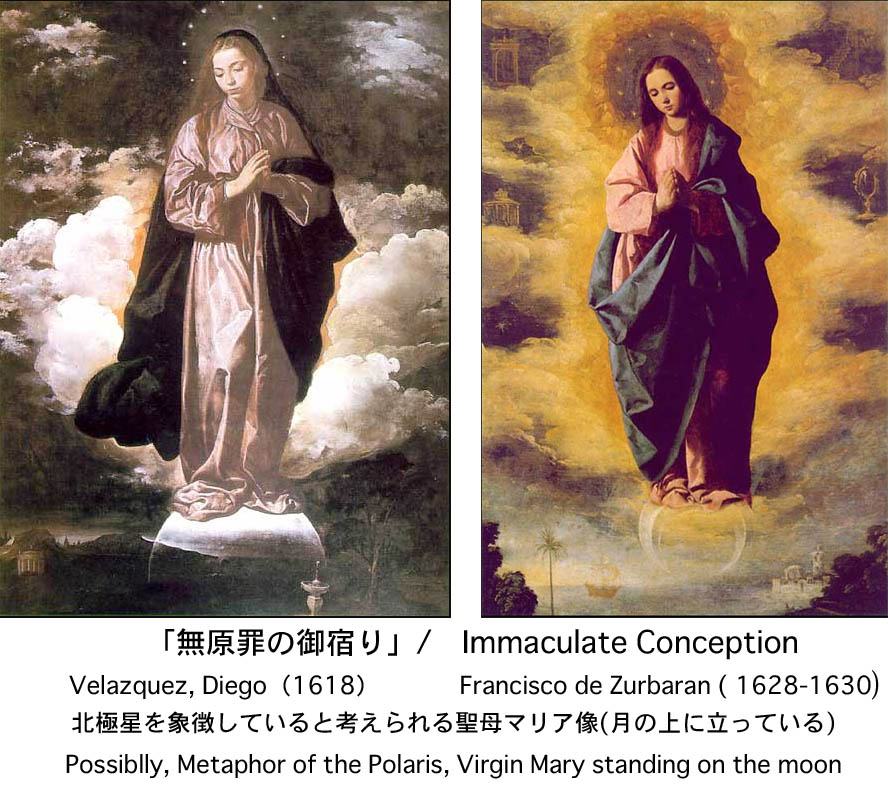
7:電波塔、VOR/DME、青函トンネル・更新され続けるライン
このサイトで紹介した4本のラインをGooglemapで拡大しながら辿って行く中で、かなりの数の電波塔や放送施設が並んでいることに気が付いた。またこのライン③と④の付近には合計5つの航空機運行に欠かせないVOR/DME施設の円形の形を確認することが出来る。内訳は全国に13あるVORTACのうち、大子VORTAC(09)と御宿VORTAC(00)の2施設と、全国に71あるVOR/DMEの3施設、大館/能代空港(31)、山形Yamagata(19)、成田空港(03)がそれぞれ最大誤差2.14kmの中に確認する事ができる。またその誤差2.14kmをライン幅としてライン陸地通過部分の総延長890kmをかけるとこのラインの総面積が1904.6km2が算出できるが、これは日本国土の総面積378000km2の約0.5%に相当し、VOR/DME施設の集中度という観点から比較すると平均の9.8倍、特にVORTAC(全国総数13)については、複数の航路が集中する大子VORTAC(09)と、ラインの南端に首都圏航空運行の要である御宿VORTAC(00)があるが、数では13:2であるが、面積密度は30.5倍になる。(下図参照)つまり千葉から東北にかけてこのラインは航空の運行を司る背骨の様に見えるが、交通ということでは青函トンネルの竜飛岬側入り口がこのラインに重なっており、約5kmラインと並走し北上するのも興味深い。(38) 放送関連の電波塔に関しては私がこのライン③と④の間に見つけたのは計6基あったが、放送塔全国総数の情報がないので、密度に関して全国平均との比較はできないが、もし放送塔をこの密度で全国規模で設置するならば、国土は電波塔だらけになってしまうであろう。またライン北端の神威岬の端には電磁台跡(52)というものがあり、現地の説明板の写真から読みとると、日露戦争時にロシア艦隊の監視、通信用に作られた施設の痕跡ということである。またウィキペディアの神威岬の電磁台についての記述によれば、「電磁台(電波探知塔)1942年(昭和17年)、太平洋戦争中に設置されたレーダーの跡。」とある。
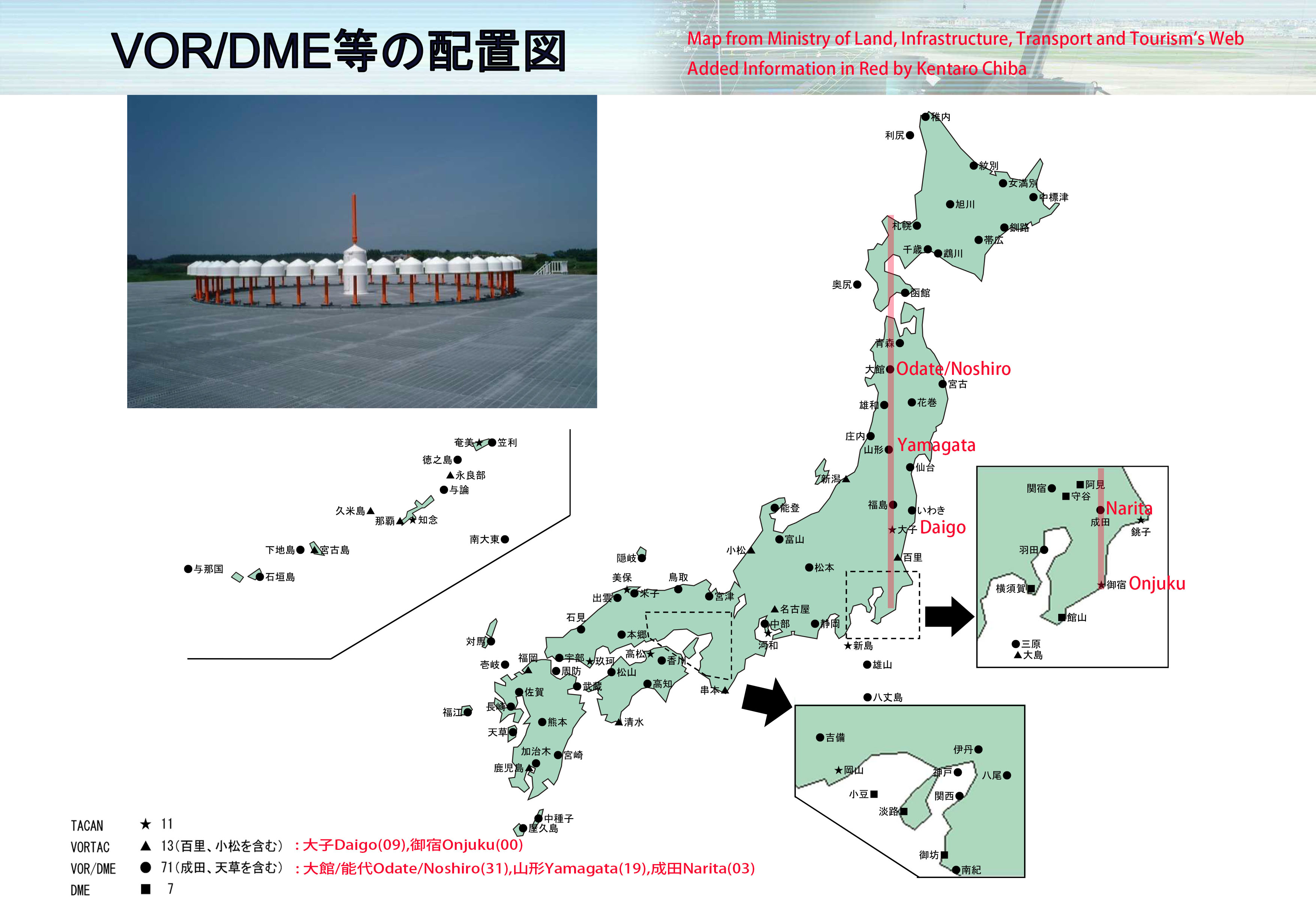
7:Antennas and Broadcasting Towers / Living line
Not only on this Longitude Line③ but also latitude Line①and Line②, we will find there are a lot of antennas in alignment. On this Longitude Line③ , besides that, I found several substations and telephone exchange centers as well. I am not sure this phenomenon are a just chance or an invisible power of Genius loci or an intentional alignment without enough information and knowledge but I personally think that a kind of visual synchronicity or strange conincidene might be visualized in category of electric towers in modern time becuase if the total gross area of this scroll maps and number of electric towers would be multiplied as the same size as the Japanese territory, our country will be full of electric towers. In other words, these lines must still be alive and continually changing. It is nothing but they are ‘Mnemosyne Atlas' suggested by Aby Warburgdrawn on the earth.I also realized a lot of observatories and view points in vicinity of the lines but its reason would be explained that high and good prospected places are very important to decide and lay lines if these alignment lines have actually existed. Here is the diagram where antennas and broadcasting Towers found between the Line③ and ④are shown below. Is it be too romantic to consider this line itself as the symbol of a cosmic antenna tower?