大地のスクロール:
太陽の道 出雲から房国へ
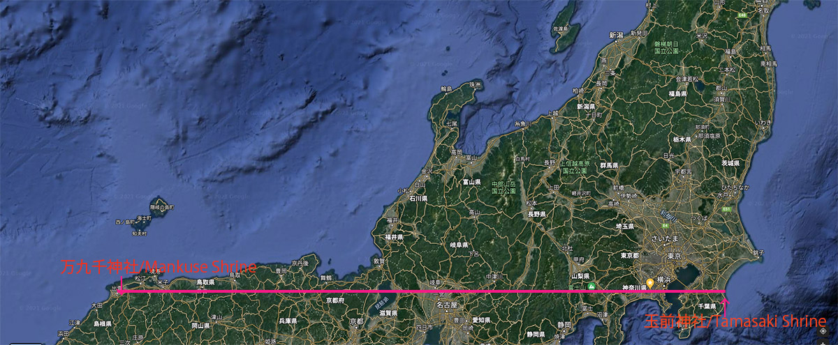
②復路 35°22′30″N 万九千神社-玉前神社 / 出雲-大山-富士山-房国ライン
Scrolls on the ground:
Equinox Sun roads from Izumo to FusanoKuni,
② The homeward 35°22′30″N , Izumo-Mt.Daisen-Mt.Fuji-Fusanokuni
![]()
29 28 27 26 25 24 23 22 21 20 19 18 17 16 15 14 13 12 11 10 09 08 07 06 05 04 03 02 01
八百万神出雲最終集合地点としての万九千神社
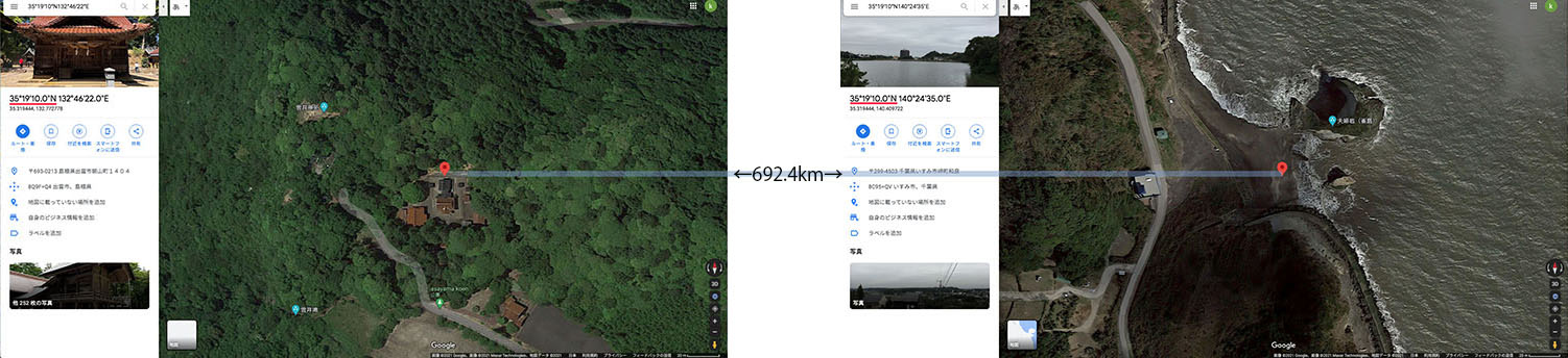
万九千神社は神在祭で全国から出雲に集まった八百万神が帰還の際に、主な滞在地である出雲大社を出発後に出雲で最後に立ち寄る場所として知られている。この万九千神社から686km隔てた東の同緯度には神武天皇の母である玉依姫を祀った上総一ノ宮玉前神社が太平洋を望む千葉県一之宮市に鎮座している。この二つの地点を結ぶ東西ライン(緯線)を引くと、いくつもの重要な歴史スポットや、大山、富士山という、日本でもっとも雄大で、古来より神聖視された二山がライン上に浮び上ってくる。万九千神社には次のような伝承が伝わる。「神在祭(毎年の神在月、旧暦10月)に際し、全国から出雲へと参集された八百万神が最後にお立ち寄りになるとの神話を今に伝えています。 八百万神は当社において、出雲路における神議り(かみはかり)を締め括り、神宴(直会=なおらい)を催したのち、神在月26日から翌未明にかけて諸国へとお旅立ち(神等去出=からさで)なさるとされています。」(万九千神社ホームページから)つまりこのライン②は神々の帰還の路の出発点であり、朝山神社を西端に置き、八百万の神々の出雲での最初の集合地とするライン①と対を成していると類推される。
Mankusen-Shrine as the last place where gods gather
When myriad gods gathered from all over the country at Kamiari-sai festival held in Izumo district return to their homeland after visiting Izumo Taisha-shrine, as the main destination and other places, Mankusen-Shrine has been known as the last place where gods gather just before their departure.On the other hand, Tamasaki-Shrine facing the Pacific Ocean in Chiba prefecture, is located at the same latitude point as Mankusen-Shrine. There is 686.5km distance between these two shrines. Tamasaki-Shrine has been regarded as the highest ranked shrine in Kazusa district (northern part of Chiba prefecture) and famous for its main enshrined deity, Tamayori-hime, Goddess Princess Tamayori who is the mother of the first Emperor Jimmu.
If the long latitude line is drawn between Mankusen-Shrine, as the west end and Yamasaki-Shrine as the east end, many important historical spots, ruins and Mt. Daisen and Mt.Fuji emerge on this line. Needless to say, Mt. Daisen and Mt.Fuji are the most magnificent and sacred mountains in Japan.
According to the legend of Mankusen-Shrine, ‘ On the last stage of Kamiari Festiva (held in every Kamiari month, November in new calendar, October in old calendar), myriad gods from all over the country have the last conference and farewell party at Mankusen-Shrine then they return to their homeland at the late night of October 26th and in the early morning, 27th (in old calendar) ’ ( from Mankusen-Shrine official website)
Therefore, it is conceivable that Mankusen-Shrine is the departure point of the myriad gods’ returning road, the line ②, which consists of the perfect pair with the line① as the coming road to Izumo where the first assembly place is supposed to be Asayama-shirine
夕暮れの稲佐の浜
出雲大社の海の玄関。八百万の神を迎える儀式が旧暦の10月10日に出雲大社によって催される。八百万の神は前日に朝山神社に集まり、一夜を過ごし。10日の夕刻にこの浜に上陸すると伝えられる。
Inasano-Hama Beach at dusk,
the sacred sea entrance to Izumo
Taisha-shrine where a welcome ceremony for myriad gods is held by Izumo Taisha-shrine priests October 10th (in old calendar). Gods gathered and stayed at Asayama Shrine on the previous day and land on the beach in the evening of 10th.
神等去出祭翌朝の日の出
八百万の神を送る儀式が旧暦の10月26日に万九千神社によって催される。八百万の神は万九千神社に集まり、一夜を過ごし。26日の夜に万九千神社よりお立ちになると言われている。手前を流れる川は斐伊川。対岸中央の森が万九千神社である。
The rising sun and Mankusen-Shrine (in the middle) in the next morning of the farewell ceremony on October 26th (in old calendar) for ‘Yaorozunokami’, myriad gods. Makuse Shrine is located in the front forest on the opposite bank. The river is Hii River.
The farewell ceremony for myriad gods are held at Mankusen-Shrine October 26th (in old calendar) every year. It is believed that deities gather and spend a night at Mankuse Shrine on that day and leave to their home land until the next early morning.
『ご来光の道とこの復路35°22′30″N万九千神社-玉前神社 ライン』
これまでにも、ご来光の道、つまり出雲大社、大山、元伊勢内宮皇大神社 (京都府福知山市)、竹生島(琵琶湖)、七面山、富士山、寒川神社、玉前神社が東西に一列に並んでいるとされるラインが提唱され、よく知られているが、残念ながらこのご来光の道上に並べられた地点の間には最大7kmほどの幅、つまり誤差があるので、このラインは意図されたものではなく、単なる偶然の産物であるとの批判が多い。しかしラインの西端を出雲大社ではなく、神々の最終集合地である万九千神社にすると、元伊勢、竹生島は大きく外れるので除外せざるを得ないが、大山については山頂の350m北を通過(26) 、七面山山頂は約500m南に逸れるが七面山信仰の場である敬慎院とは150mの誤差(08)、富士山については、山頂のお鉢巡りの一つである火口の北端にある白山岳とは1kmの誤差(06)、寒川神社については本殿とは500mの誤差があるが、一の鳥居から始まる約1Kmの参道のほぼ中央を通過し(04)、東端の玉前神社(01)に至る。玉崎神社本殿はラインより100m北に位置しているが、玉崎山観明寺(明治神仏分離令の前は玉崎神社と一体であった。)と玉前神社社号標が正確にこのライン上にある。ライン全体では、最大南北誤差は富士山火口の白山岳の約1kmであるが、全長686.5kmを考えると非常に正確に引かれていると言えるのではないか。また以上の他にも出雲國一之宮熊野神社(150m南)(28)などの重要なスポットもあり、さらに近年発掘された荒神谷遺跡(ほぼ誤差なし)(29)などがこのライン上に位置しており、まだまだ未発掘、未発見の遺跡やスポットがあるのではないだろうか。Line ②, the homeward 35°20′30″N line, stems from Goraiko-no-michi.
Goraiko-no-michi, the road of sunrise, the most famous lay line in Japan has been well-known and suggesting the amazing alignment on the line where many important historical and geographical points are shown in a line such as, Izumo-Taisha Shrine, Mt. Daisen, Moto-Ise Kotai-Jinja Shrine (Kyoto Fukuchiyama-city), Tikubu-jima Island (Biwa-ko Lake), Mt. Shichimen-san, Mt. Fuji, Samkawa-Shrine and Tamasaki-Shrine. But unfortunately, Goraiko-no-michi has about 7 km width in location, it is nothing but 7 km error. But if Mankusen-Shrine is set as the west end of the line instead of Izumo-Taisha Shrine, the differences would be within 1km, although Moto-Ise Koutai-Jinja and Tikubu-jima Island have to be excluded because of their location differences.Examining, each point one by one, as for Mt. Daisen, its summit is located 350m north of the line(26). Mt. Shichimen-san, is located 1km south of the line but Keisin-in Temple, the main building for worshipping to Mt. Shichimen-san is fixed at the point 150m north from the line(08). With regard to Mt. Fuji, Hakusan-take, the northernmost peak of Mt. Fuji’s 8 crater peaks is located 1km south of the line(06). Concerning Samkawa-Shrine, there is 500m distance between its main shrine building and the line, but the line travels across in the middle of its 1km approach road extend in a north-south direction(04). The line finally reaches Tamasaki-Shrine as the east end. Regarding Tamasaki-Shrine, the line deviates from Tamasaki-Shrine’s main building 100m north but accurately crosses Tamasaki-San Kanmeiji-Temple, which used to be a part of Tamasaki-Shrine before the ordinance to distinguish Shinto and Buddhism in 1868 and Tamasaki-Shrine’s old name post stone pillar is still standing on the middle of the line(01).
Examining location differences in the whole line, the most one is Hakusan-Take peak in Mt Fuji’s crater, there is 1km difference but considering the whole length of the line, 686.5km, it would be possible to say the line was fixed very accurately in ancient time.
Besides these spots above, there are several other important spots have appeared on the line, e. g. Kojin-dani Ruin discovered in 1983 (29)and Kumano-Taisha, considered as the most important shrine in Izumo district(28) and has been playing very important role during Kamiari-Festival as well.